Taranga
Taranga is a rural area in north Gujarat, India. Taranga is a major Jain pilgrim centre due to its 11-12th century Jain temples. There are some Buddhist archaeological remains and temples of interest. It is also visited by trekking and forest enthusiasts.
Understand
There are no lodging or boarding facilities in the area except for Jain pilgrims and the nearest Timba village has not much facilities either. The place is isolated and best visited by private vehicle only as there is no public or private transport.
Get in
Most state transport buses drops passenger at 🌍 Timba Chowkdi. ![]()
![]() on Mehsana-Visnagar-Ambaji Highway. Shuttle Vehicles also drops passengers here. From here, Taranga Hill Road starts to reach above the hill. It is difficult to get transport to hill except on major festival days from Timba Chowkdi or railway stations. So it is best suited to have your own private vehicle.
on Mehsana-Visnagar-Ambaji Highway. Shuttle Vehicles also drops passengers here. From here, Taranga Hill Road starts to reach above the hill. It is difficult to get transport to hill except on major festival days from Timba Chowkdi or railway stations. So it is best suited to have your own private vehicle.
Get around
Private vehicle is an only feasible way to move around. Several sites of interest are located on the hillocks which need climbing steps and a bit of trekking.
See and do
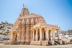
- 🌍 Ajitanatha Jain temple. The large 12th-century Jain temple built by Chaulukya ruler Kumarapala in late Maru-Gurjara architecture style.

.svg.png)
- The two hillocks named 🌍 Siddhashila. and 🌍 Kotishila. have shrines with idols of the Tirthankaras, Neminath and Mallinath dated Vikram Samvat 1292. One need to climb 500 and 700 steps respectively to reach the top of hillocks. They also provide an excellent view of the surrounding landscape.
- There are 🌍 14 Digambara temples in the foothills. The oldest temple in foothill compound dedicated to Sambhavanatha was built in Maru-Gurjara architecture in 11th century.
- 🌍 Taran-Dharan Mata shrines (About 2.5 km north of the hill). The shrines of Taran Mata and Dharan Mata is situated near a natural stream. The idol of Taran Mata is dated to 8th-9th century based on its style.
- 🌍 Buddhist Stupa remains. (Near Taran-Dharan Mata shrines). Brick structures and other archaeological remains were found near the seasonal stream.
- 🌍 Jogida ni Gufa (Taranga Buddhist caves). Buddhist sculptures and rock shelters atop the hill. Need some trekking to reach there.
- 🌍 Tapovan Digambar Jain temple (on the way to Ajitnatha temple).
- 🌍 Tirthankar Van (Tapovan botanical garden). Good for family picnic.
- 🌍 Nilkanth Vav Jal Mandir. A small square stepwell built in 1830.
- 🌍 Rock climbing at Frog Rock. Rock climbing should be performed only with help of suitable equipment and team as this is very isolated place.
- 🌍 Fortification remains. Located in southwest of hill, this fortification remains are probably from 3rd or 4th century BCE. There are probable place of historical Anarta/Anandpura. One has to trek difficult forest to reach there. Help from experienced local trekker is must.
Buy
Eat
- 🌍 Taranga Jain Bhojanshala.
Drink
Sleep
Connect
There is no hopsital nearby, nearest being the Primary Health Centre in Satlasana (5 km away).