Delta de l'Ebre Natural Park
Delta de l'Ebre Natural Park is in Tarragona (province) of Country. One of the most emblematic birds of the Delta are the flamingos, which are present all year round. The Ebro Way of St. James starts in the park which is inside the UNESCO Biosphere Reserve Terres de l’Ebre, Catalonia.
Understand
The Ebro Delta covers 320 km²: 20% of which are natural areas (the current natural park), 75% are farmland and the rest is urban.
History
It was declared a protected area in 1983, and was later expanded in 1986 to cover 7,736 hectares. The protection of this area had a precedent in 1962 when, at the request of the scientific community, the Ebro Delta was included in the classification of Euro-African wetlands of the Bureau MAR with the category of urgent priority. In accordance with a directive of the European Economic Community on the conservation of birds, it was declared a special protection area. The protection was extended in March 1993, by which the park was included in the list of wetlands of international importance (Rāmsar Convention), especially as a habitat for waterfowl. In 2013, UNESCO declared the Terres de l'Ebre Biosphere Reserve, which included the Ebro Delta Natural Park, in addition to other areas.
Landscape
The Ebro River brings the materials torn up along its course to deposit them here, in conjunction with the Mediterranean Sea. The amount of sedimented materials have created an extensive alluvial plain, which projects nearly 22 km into the sea in the shape of a wedge, and in which numerous habitats have formed. The large hydroelectric power plants have created large dams that have slowed the growth of the delta and even caused it to retreat due to lack of sediment.
Flora and fauna
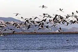
The lands of this delta have a notable salinity gradient that ranges from salty soils to fertile lands that are considerably suitable for cultivation, and this generates a variety of vegetation of great interest. For this reason, the plant mass of these places offers notable particularities. The reed beds and reed beds are of extreme importance. The vegetation that occupies the banks of the river corresponds to the only forest communities of the delta, that is, the well-known riparian forests, among which the white poplar (Populus alba), especially present on the Illa de Gràcia, stands out. The humidity of the Ebro delta (including the park) is of international importance for eight species of plants and 69 of vertebrate fauna, most of which are birds. There are nests of 95 species, where they winter, rest and feed during the migrations of many other species of birds. The Ebro Delta has about 325 species of birds out of the 600 existing in Europe.
Climate
Tourist office
- 🌍 Park Main office (Parc Natural del Delta de l'Ebre Seu administrativa), Av. Catalunya, 46, 43580 Deltebre, ☏ +34 977 48 21 81.

.svg.png)
- 🌍 Ecomuseu, C/ Doctor Martí Buera, 22, 43580 Deltebre, ☏ +34 977 48 96 79.
- 🌍 Casa de Fusta, Bassa de l'Encanyissada-Partida de la Cuixota, 43870 Amposta, ☏ +34 977 26 1022.
Get in
By plane
- Reus Airport REU IATA: Located approximately 100 km from the park, it offers a convenient option for travelers with limited international flights.
- Barcelona El Prat Airport BCN IATA: While further at about 200 km, it offers extensive international connections and better public transport
By train
- 🌍 Estacio L'Aldea-Amposta, Arrabal de San Ramón, S/N, 43896 L’Aldea, ☏ +34 912 320 320. For high-speed trains to Barcelona and Valencia.
By bus
- 🌍 Tortosa Bus Station (Estació d'autobusos de Tortosa), Carrer d'Adrià d'Utrecht, Tortosa.
- There is a bus service from Tortosa to Riumar passing by L'aldea train station and Deltebre.
By car
To get to Amposta
and the to the park
- TV-3454 , T-340 to access the north side
- TV-3403 , TV-3404 , TV-3405 and TV-3406 to access the south side
By boat
- 🌍 Club nautic La Rápita, Avinguda dels Alfacs, 2, 43540 La Ràpita, ☏ +34 977 74 11 03. In La Rápita there is a marina for sport and fishing ships
- 🌍 Club Nàutic Riumar, Port de Deltebre - Riumar, Riumar , Deltebre, ☏ +34 977 470 618, cnriumar@cnriumar.com.
- 🌍 Club Nàutic Ampolla, Av. Marítima Ramon Pous s/n, 43895 l'Ampolla, ☏ +34 977 460 211, port@nauticampolla.com.
By foot
By bicycle
Fees and permits
Get around
Parking
- 🌍 Motorhome parking Área de la Casa de Fusta, Camí de les Casetes. paid.
- 🌍 Motorhome parking Área Pas de barca de Fermin.
- 🌍 Motorhome parking Área Sant Jaume d'Enveja (Àrea d'autocaravanes de Sant Jaume d'Enveja), TV-3403 - Passeig de la Segregació. free.
- 🌍 Motorhome parking Área Ràpita (Area Municipal de Autocaravanas Ràpita). free.
- 🌍 Motorhome parking Área Perelló Mar, Carrer de les Oliveres, Perelló - Mar, el Perelló. no services
- 🌍 Motorhome parking Área Camarles, Carrer Trenta, Camarles.
- 🌍 Motorhome parking Área els Muntells, Carrer Major, els Muntells, Sant Jaume d'Enveja,.
- 🌍 Parking Trabucador, Camí del Trabucador, la Ràpita. no motorhomes at night. free.
- 🌍 Parking lo Passador, Carrer de Sant Joan.
See
- 🌍 The Tancada lagoon (La llacuna de la Tancada). a good place to observe flamingos. It has 3 birdwatching points (See #Birdwatching )
- 🌍 The Encanyissada (L’Encanyissada). a large submerged meadow. It is the largest lagoon in the Ebro Delta - it covers about 900 hectares and has a depth of 114 cm. It is naturally connected to the sea, with the Alfacs Bay, through the Gola Vella. It has 3 birdwatching points (See #Birdwatching ):
- 🌍 The Baltasar fangs (Els ullals de Baltasar). when water emerges from the ground. They are underground springs in the Ebro delta. They are caused by rainwater that flows through the aquifer from the Port and Montsià massifs towards the sea, and that, when encountering the deltaic materials, already saturated, are forced to emerge. They are circular-shaped basins. There is a recreational area.
- 🌍 The Punta de la Banya. the jewel of the Park (restricted access). It is the largest natural area in the Delta and one of the most important breeding areas for water birds (seagulls, terns, waders and flamingos) in the Mediterranean. A part it is under concession for natural sea salt exploitation (the so-called Salines de la Trinitat)
- 🌍 les Olles pond (Bassa de les Olles). This extensive area begins at Arenal beach and extends to Goleró, connecting with Fangar Bay and bordered by rice fields on the inland side and a well-preserved dune strip on the marine side.
- Mouth of the Ebro. the last frontier. It includes the protected natural areas of Garxal, Sant Antoni Island and Buda Island. Magnificent panoramic views from the Zigurat viewpoint.
- 🌍 Buda island (l'Illa de Buda). the last island (restricted access). Is a maritime-fluvial island. It covers about 1,100 hectares, of which about 250 are rice fields. This diversity of environments, both quite extensive and well preserved, allows Buda to be one of the areas of greatest natural interest in the entire delta, and to host very large populations of aquatic birds, both nesting and wintering.
- El Migjorn. a river arm that does not always reach the sea. Runs along L'illa de Buda and is a 3.5 km long arm of the river that was once the mouth of the main river. It now has the characteristics of a long, narrow channel, and functions more like a lagoon than a river. It is flanked by reedbeds that are home to many passerines and anatidae.
- 🌍 El Garxal. the most recent pond. It is a very shallow lagoon in full formation, with great dynamism. Its origin is very recent. It dates from the mid-20th century, when the current gorge opened during a storm, replacing the previously North gorge. El Garxal is formed by small crescent-shaped islands that change shape according to the deposition of sediments that the river brings. The pond or lagoon is surrounded by a very well-preserved dune ecosystem and is fixed by vegetation, mainly tamarisk (Tamarix canariensis). Freshwater enters exclusively through the river, since no drainage canal from the rice fields flows into it. Exchange with seawater occurs during storms
- 🌍 Punta del Fangar. a desert surrounded by water. This is an extensive coastal strip that includes the best-built system of sandbanks and mobile dunes in the Delta. A compact sand track crosses the Fangar, which you can drive or walk along until you reach the middle, the viewpoint, the lighthouse or the northern end of the peninsula. Between April 1 and August 15, it is forbidden to enter the nesting areas, which are protected by the cordons on the edge of the track. Immense sandbanks predominate in this area and what has the greatest ecological value are the dune formations, as they are among the best preserved on the Catalan coast. They constitute an important refuge for many reptiles, insects, micromammals and some amphibians. There are two types of dunes, some fixed with vegetation on top and others mobile without vegetation. You cannot walk on either of them due to their fragility. The most important fixed dune area is located on the Marquesa beach, to the right of the track that reaches the Fangar. The characteristic Fangar lighthouse stands in the middle of the dunes.
- 🌍 Canal Vell lagoon (La llacuna del Canal Vell). the origin of the Park. Until the 1970s it had been the largest in the entire delta, but the intense exploitation of the surrounding rice fields and the construction of bypass canals caused the area to lose its extension. Of the three basins that were initially there, only two remain: Estella and Illot. Freshwater enters through three drains, while seawater arrives through two. The lagoon is privately owned, and the Canal Vell Biological Station is located there.
Itineraries
Do
Hiking
- long range
- 🌍 Start of Ebro Way of St. James, Passeig maritim , Riumar.
- 🌍 Start of Ebro Way of St. James, Passeig maritim , Riumar.
- local hikes
| Route# | Name | Distance | time | Dificulty |
|---|---|---|---|---|
| 5 | Desembocadura-Garxal-Riumar | 6,9 km | 1 h 45 min | eassy |
| 9 | Passeig fluvial del Deltebre | 12,6 km | 3 h | eassy |
| 10 | Bassa de les Olles | 3,3 km | 1 h | eassy |
| 12A | Ullals de Baltasar | 0,9 km | 30 min | eassy |
| 12B | Bosc de Ribera | 1,2 km | 30 min | eassy |
| 13 | El Serrallo | 1,9 km | 45 min | eassy |
| 14 | Punta del Fangar | 8,4 km | 2 h 15 min | eassy |
Cycling
| Route# | Name | Distance | time | Dificulty |
|---|---|---|---|---|
| 1 | Ruta de les llacunes | 28,8 km | 4 h | eassy |
| 2 | Ecomuseu-Desembocadura | 31,4 km | 5 h | eassy |
| 3 | Ecomuseu-Badia del Fangar | 17,2 km | 3 h | eassy |
| 4 | L'Aldea-Camarles-l'Ampolla | 24,5 km | 4 h | eassy |
| 5 | Desembocadura-Garxal-Riumar | 6,9 km | 1h | eassy |
| 6 | Amposta-Ullals-Casa de Fusta | 27,7 km | 4 h | eassy |
| 7 | Sant Carles de la Ràpita-Casa de Fusta | 25,4 km | 4 h | eassy |
| 8 | Camí de Sirga | 45 km | 6 h | Mid level |
| 9 | Passeig fluvial de Deltebre | 12,6 km | 2 h | eassy |
| 11 | Sant Jaume d'Enveja-Els Muntells-Eucaliptus | 19,3 km | 3 h | eassy |
Birdwatching
L'Encanyissada
La Tancada
Bassa de l'Alfacada
Garxao Gran
- 🌍 Mirador del Passeig Fluvial.
- 🌍 Mirador Zigurat.
- 🌍 Mirador del Garxao.
- 🌍 Mirador del Garxal.
- 🌍 Mirador de Riumar.
Les olles
Punta de la Banya
- 🌍 Mirador de la Punta de la Banya.
Events
Beach & sunbath
Water sports & Sailing
- 🌍 mirador badia, Plaça Gonzalez Isla, s/n, 43895 l’Ampolla, ☏ +34 676 331 938. boat trips, boat trips with aperitive, visit mussel farm from €45.
Kid activities
Buy
Around the park there are rice crops and high quality salt producers. Buy at the local shops in the villages around the park.
Eat
- 🌍 Deltaic, av. Generalitat, 75. 43580 La Cava, Deltebre, ☏ +34 621 214 802.
- 🌍 Restaurante La Barraca, Passeig de l’Arenal, s/n – 43895 l’Ampolla, ☏ +34 977 46 06 81, restlabarraca@gmail.com. Rices and shellfish. tipical cooking from the area.
- 🌍 Arrocería y Casa Rural Mas Prades, Crta. T-340 Km, 43580 Deltebre, ☏ +34 977 059 084, masprades@gmail.com. rice
- 🌍 Restaurant Nuri, T-340, ☏ +34 977 48 01 28, restaurantnuri@live.com. Tu-Su 12:00-17:00.
Picnic
Drink
There are bar & cafeterias in the villages around the parc
Sleep
Camping
- 🌍 Camping Aube, Cami del Camping, 1 Urb. Riumar, 43580 Deltebre, ☏ +34 977 48 99 04, aube@capfun.com.
- 🌍 Càmping Eucaliptus, TV-3405, Urb. Eucaliptus, Amposta, ☏ +34 977 47 90 46, info@campingeucaliptus.com.
- 🌍 Taiga Delta de l’Ebre, Passeig Platja Arenal, 30 , L'Ampolla, ☏ +34 977 460 535, hola.ebre@taigaresorts.com.
- 🌍 Camping Alfacs, Avinguda del Mar 1, Alcanar (2 km from Sant Carles de la Ràpita), ☏ +34 977 74 05 61, info@alfacs.com.