Coulterville
Coulterville (formerly, Maxwell's Creek) is an unincorporated community in Mariposa County, California. It is located on Maxwell Creek 20 miles (32 km) northwest of Mariposa at an elevation of 1699 feet (518 m).
Understand
It is located at the western foot of the Sierra Nevada mountain range in central California, and has an average altitude of 518 m. It was formed as a mining village in the 1850s as California Gold Rush, and has about 115 residents, as of 2020.
Get in
Sacramento is 187 km to the northwest and Mariposa, the county's administrative center, is 43 km to the southeast.
State roads 42 and 132 pass.
Get around
See
- 🌍 Northern Mariposa County History Center, 10301 Highway 49, ☏ +1 209-878-3015, nmchc1@gmail.com. W-Su 10AM-4PM.

.svg.png)
Do
Buy
Eat
Drink
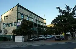
Sleep
- 🌍 Hotel Jeffery, 1 Main Street, ☏ +1 209-878-3471, info@hoteljeffery.com.
- 🌍 Yosemite Springs, 6986 Greeley Hill Rd, ☏ +1 209-878-3835. Offers camping, airstreams & a bed and breakfast. Less than 20 mi (32 km) from the W. entrance to the park.
Connect
Go next
| Routes through Coulterville |
| Auburn ← Jamestown ← | N |
→ Mariposa → Oakhurst |